

FLYING Magazine
Centrally located in the San Francisco Bay Area, Hayward Executive Airport (KHWD) in California might just be a good place for a pilot to use to gain access to the many attractions in the area. The RNAV GPS RWY 28L approach is a way to get down to the airport when weather conditions are less than optimal VMC.
If you’re not already a subscriber, what are you waiting for? Subscribe today to get the issue as soon as it is released in either Print or Digital formats.

A. Two Runways
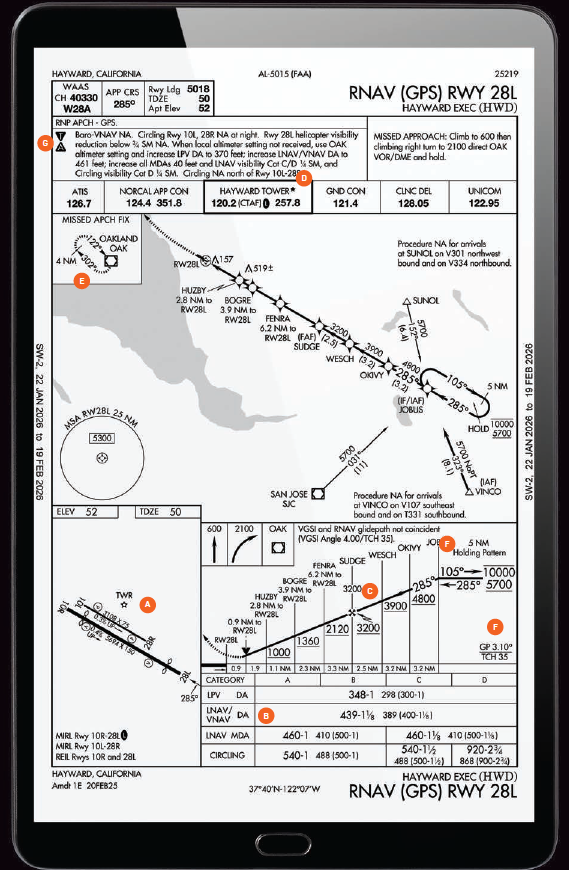
The title of the chart notes that the approach is to Runway 28L, indicating it is the approach for the “left” runway. This tells us there are two runways and that the approach is to be used to 28L only. You can see the two runways depicted on the airport diagram on the lower left of the approach plate. Make sure you’re set up for the correct runway as you break out in visual conditions to complete a landing from this approach, unless you happen to be circling.
B. WAAS or Non-WAAS Minimum Options
The minimums section on the bottom of the approach plate offers LPV, LNAV/VNAV DA, LNAV MDA, and circling minimums. For WAAS-equipped aircraft, the LPV minimums offer a glide slope and a “DA” (decision altitude), making this approach “precision-like” and taking a pilot down to 348 feet msl (298 feet agl). A non-WAAS-equipped aircraft would have to fly to a higher minimum.
- READ MORE: Autonomous Aircraft Vertiport Coming to California’s Hollister Municipal
- READ MORE: NGPA Industry Expo Draws Thousands to California
C. If Non-WAAS, Stepdowns
A pilot flying this approach using the LNAV MDA altitude needs to sequence through a variety of stepdown fixes. When starting at the IAF at JOBUS at a minimum altitude of 5,700 feet msl, they could start the descent to 4,800 feet msl and maintain until passing OKIVY, then descend to 3,900 feet msl until WESCH, cross SUDGE to the final approach fix at 3,200 feet msl, and progress inbound and downward to 2,120 feet msl at FENRA, 1,360 feet msl at BOGRE, and 1,000 feet msl at HUZBY, and continuing to 460 feet msl as the MDA for the LNAV minimums. Each of these stepdowns should sequence through in an IFR GPS, notifying a pilot of their passage.
D. If Circle, Circle to the South
There’s no approach to the airport for Runway 10R, so if you need an approach to this airport when there’s an east wind, you’ll need to fly an approach to 28L and then circle to land. A note on the chart indicates “Circling NA north of Rwy 10L-28R.” This is an indication that a pilot wanting to circle from this approach to 10R needs to circle to the south of the airport, in right traffic, at an appropriate altitude for their approach speed category.
E. Missed to the VOR, HOD NM Distance
If a missed approach is needed, the pilot will initiate a climb to 600 feet msl, then make a right turn to the OAK VOR while climbing to 2,100 msl. The hold will be on an inbound heading of 122 degrees after the pilot has executed a hold entry. While many of us remember holding on VORs with standard one-minute legs, this hold is depicted as 4 nm legs. Let your GPS do the work for you here and make it easier than the old school method of timing the legs of the hold.
F. Glide Slope Differences
The glide slope from the approach and the visual glide path indicator on the left of the runway, a VASI, are not “coincident” on this approach as is noted. A pilot should expect the visual glide slope to be a little steeper, 4.0 degrees, while the glide slope on the approach will be a slightly lower 3.1 degrees. The practical application is that you may find yourself looking like you’re below the visual glide slope indicator while you’re flying the approach glide slope.
G. Troublesome ‘T’ and Alternate ‘A’
In the upper left, you will find two notations—an upside-down triangle with a “T” in it and a right-side-up triangle with an “A” in it. These are specific notations that should drive the pilot to look at some more information found in the TPPP/approach binder. The T is an indication that “nonstandard takeoff minimums” apply for this airport. It can spell trouble if you don’t pay attention. In this particular case, specific climb gradients are required depending on the departure runway used, and a variety of obstacles are listed near the airport. These are “low, close-in obstacles” located within 1 nm of the departure end of the runway, but don’t penetrate the obstacle-clear surface area. Still good to know about. The “Alternate A” means that nonstandard IFR alternate minimums exist for the airport. Also referenced in the TPPP, in this example, you would find there are limitations for using this airport as an alternate when the tower is closed, local weather is not available, and for specific approach category aircraft.
This column first appeared in the July Issue 972 of the FLYING print edition.